

Keep Direction By Good Methods
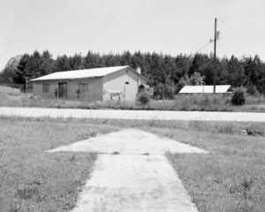
32 A–NY, South Carolina. Codes for each beacon site register the route – in this case, Atlanta to New York City – and distance along the route – in this case, 320 miles. [All photographs by Chris M. Forsyth, 2019]
Almost a century ago, a network of analog signals — towers, beacons, giant concrete arrows guided airmail pilots across the country.
Photographs By Chris M. Forsyth. Text By
DAEGAN MILLER.
Flashes of light pulse through the dark, a repetitive rhythm transmitted in Morse code, marking a path in a void.
One by one, each letter from the string WUVHRKDBGM whose logic is visual, building predictably from dashes to dots and back again, rather than alphabetic one by one, each signaled letter beams at many millions of candlepower from beacons 51 feet high, one beacon every ten miles, strung across the U.S. from New York to San Francisco:
.——
..—
…—
.—.
—.—
—..
—…
——.
——
Ten flashing bits of code, for which the pilots pioneering transcontinental U.S. airmail made a mnemonic: “When Undertaking Very Hard Routes Keep Direction By Good Methods.” This simple system is what made coast-to-coast airmail viable in the decades after World War I. 1
Flight became an obsession in the United States in the 1920s, and Icarian daredevils dreamed of flying higher, farther, faster. Charles Lindbergh winged his solo way nonstop from New York to Paris aboard the Spirit of St. Louis in 1927. The next year, Amelia Earhart became the first woman to cross the Atlantic, going on to set a slew of other records and then vanishing in the South Pacific. The obsession kept pace with technological development, and it was only 20 years later that Chuck Yeager shattered the sound barrier. Two decades after that, Neil Armstrong and Buzz Aldrin made the leap to the moon. You know their stories, have seen their photographs modern myths of humans turned into heroic machines.
But humbler dreamers also wanted quick, long-distance communication: the transplant to another town, yearning for a word from home; the businessman, eager to conduct his affairs at the speed of flight. So it was perhaps inevitable that the mail would take to the sky, and the first experimental U.S. Mail flight occurred in 1911, when pilots delivered letters from Garden City, New York, to nearby Mineola a distance of one-and-a-half miles. 2 A success.
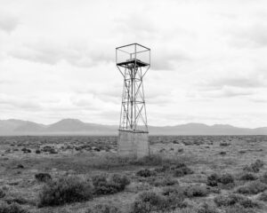
In 1920, after faster planes had proven reliable over ever-greater distances and a few rounds of Congressional funding had established an official U.S. Airmail service, a truly long-haul route was opened between New York and San Francisco. Even so, it wasn’t much faster than the older train delivery. A locomotive could chug 24 hours a day, but no one flew at night. To do so was suicidal. Aviation instruments were rudimentary there was no GPS, no radar, no in-plane radio and pilots couldn’t see in the dark. And so, beginning in the first years of the decade, the Post Office (and later the Department of Commerce, once the service was transferred to its jurisdiction) built an enormous infrastructure, a ground-based constellation. More than 1,500 beacons, developed by GE, Westinghouse, and Sperry Gyroscope, along with towers, searchlights, emergency landing fields, refueling stations, lighted wind vanes, and 56-foot-long concrete arrows laid into the earth and lit by flickering acetylene lamps on an 18,000-mile network of flight paths. 3
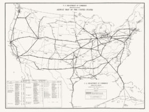
Airway Map of the United States, U.S. Department of Commerce, Aeronautics Branch, 1933. Solid black lines show the lighted routes ten years after the lighted airway system began. [via Chris M. Forsyth]
Even so, where all the landmarks are the same one can only wander blind, and those shafts of light striping the night created their own chaos. With beacons visible from 30 or more miles, a pilot might find three or four waystations beckoning at once. Which was how airmail came to rely on Morse code.
Each tower on a given route was assigned a letter in the sequence WUVHRKDBGM, flashing out its message using a simple electronic system. Since towers were spaced every ten miles, the first — the W tower — was at the ten-mile mark. Tower U was at 20 miles, V at 30, until the plane passed the M tower at 100 miles. Then the sequence repeated. All a pilot had to remember was the phrase When Undertaking Very Hard Routes Keep Direction By Good Methods and his current place in it.
By 1933, the lighted transcontinental airway system was finally complete at which point, it was obsolete. The radio towers that would replace it were already being built, and like much of what was once technologically modern, the beacons, runways, and concrete arrows now lie forgotten, littering the American landscape alongside stagnant canals and grass-filled locks, Route 66’s derelict kicks, rusting railroad tracks, mute phone booths, and a forest’s worth of tv aerials.
Or, almost forgotten. In 2019, the Montreal-based photographer Chris M. Forsyth spent eleven weeks driving across the U.S., hunting the remains of the network, guided by old maps, Google Earth, and hints from geocaching and off-roading forums. 4 He found 75 or so many in the West, where the lack of tree-cover exposed them to Google’s satellite eye, and large expanses of public land reduced the risk of trespassing. Some towers still serve small regional airports, while others lie toppled and twisted, or have been repurposed as signposts for terrestrial wayfarers. Of the concrete arrows, Forsyth located many close to current roadways, but he arrived at some only by bushwhacking his way to mountain peaks. Once Forsyth got to an arrow or a tower, he would unpack his medium-format camera, choose and load his film, and trip his shutter, for a fraction of a second long enough for a beam of light to flash across the void inside the camera’s body.
And in so doing, something curious happened: as light passes through the interior of a camera to land on the film, it flips top for the bottom and a sense of this inversion clings to Forsyth’s images. Rather than the pilots’ aerial paths through the night, his photographs show the grounded remains of a way who’s lights have gone out, its once high-tech hardware left abandoned in the washed-out sunshine of the morning after. The beacons and arrows no longer mark a confident way to a destination but point mutely to a little-known past. They unsettle, for they have become uncanny. You who gaze now at Forsyth’s landscapes on your screen are doing so via the pulsation of ones and zeroes along millions of miles of fiber-optic cable, flashes that have flown very hard routes to bring you instantaneous mail and news of the world, as well as a picture of progress crumbling into the earth.
Notes
The most comprehensive account of the lighted transcontinental airway system is in Henry R. Lehrer, Flying the Beam: Navigating the Early US Airmail Airways, 1917 – 1941 (West Lafayette: Purdue University Press, 2014). Details on tower height and light intensity can be found on pages 70 and 82. ↩
US Postal Service, Airmail: A Brief History, 2. ↩
Linda Shiner, “No Longer Afraid of the Dark,” Air & Space (September 15, 2008); Lehrer, Flying the Beam, 70, 80-81, 88. ↩
Details of the artist’s research and practice are from Chris M. Forsyth, discussions with the author in January 2021. ↩
Cite
Photographs by Chris M. Forsyth. Text by Daegan Miller., “Keep Direction By Good Methods,” Places Journal, February 2021. Accessed 28 Apr 2021. <https://placesjournal.org/article/early-aviation-keep-direction-by-good-methods/>
placesjournal.org
