

The Ice
It’s the contradictions that hold the continent together. As measured during the Austral summer, Antarctica encompasses 5,500,000 square miles (14.2 million square kilometers); almost the entire landmass 95 percent is covered in ice that doubles in extent every year as the sea freezes around it in winter. During summer, at its minimum, the continent remains twice the size of Australia, 1.3 times the size of Europe or equal to the United States and Mexico combined.
If all the ice were to disappear, the Antarctic would be the world’s largest archipelago, a series of immense islands and peninsulas separated by deep valleys. At 11,500 feet, or 3,500 meters deep, the ice-gouged abyss under the Denman Glacier is deeper than anything on the planet but the great ocean trenches.
The Antarctic is the driest, windiest, coldest, highest but also lowest continent on the planet. Its highest point is Mt. Vinson (16,050 feet; 4,892 meters), but the ice atop the continent averages a mile in-depth, and in some places is three miles thick. Such mass depresses bedrock below sea level. If all the ice melted, the rising elevation of the oceans wouldn’t just drown coastlines around the world; the continent itself would rebound upwards.
The Antarctic was the last continent to be discovered, first set foot upon by humans in 1860, and it is the least walked-upon region of Earth, but it is also the most well-mapped continent. The U.S. Geological Survey maps when the agency still printed them covered mostly coastal and mountainous regions places where there were distinguishable features like crevasses, glaciers, bays, even penguin rookeries. Dotted lines labeled “line of completion” indicated where the terrain subsided to nothing but ice, and beyond which the paper was simply left blank a white expanse. Now the entire Antarctic surface and subsurface, ice and rock alike, are imaged by satellite, yet still and forever mostly untrodden.
Antarctica is not a country but a continent governed by an international treaty and dedicated to science. There are no known mineral resources worth mining, and agriculture, the world’s other most active geomorphological agent, occurs only in a handful of greenhouses that provide fresh greens and psychological relief for people stationed there. Although the continent is nuclear-free, it sustained its greatest human invasion by military-led forces in the mid-1950s as part of the global research project known as the International Geophysical Year. The IGY actually lasted eighteen months during which the U.S. Navy and the armed forces of other countries practiced the running of conflict logistics in the extreme cold.
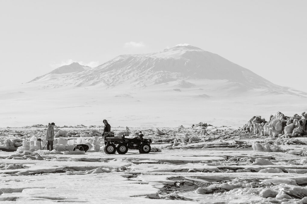
There is no soil in the Antarctic, even in the five percent of the continent not covered by ice, just regolith. Yet there are endoliths such as bacteria, lichen, and algae found in and under virtually every rock, and bacteria are found in the ice itself, including at the South Pole and in at least some of the 70-plus lakes under the ice. Commonly considered a biologically dead continent, Antarctica teems with extremophiles, a cohort which could be said to include the scientists and their support personnel, and which numbers fewer than a thousand during winter, and as many as 5,000 during summer. And then there are the tourists, perhaps as many as 70,000 in non-pandemic times, skirting the shorelines on icebreaking cruise ships. Some artists and writers on these ships do step ashore for a few hours too little time to understand the continent and its contradictions.
Yet no one remains on the ice for more than one uninterrupted year; everyone is forced to rotate off to allow their bodies to recuperate from not only the six months of dark but also the cold. It is a cold so unrelenting that it changes your body chemistry to the point where you lose a portion of your short-term memory, your ability to focus your eyes upon what is in front of your face, and indeed your equanimity. There are no people who live in the Antarctic, but many who, once having spent a season there, call it home.
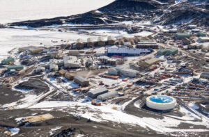
To photograph in such a place is tantamount to practicing art on another planet. The only artists who are able to fully engage the continent are those commissioned by the governments that maintain one of the six dozen or so stations on the ice. These outposts range in size from single tents to the relatively spacious structures at the larger research complexes scattered across the continent, such as Australia’s Mawson Station, Russia’s Vostok Station, New Zealand’s Scott Base, and the Amundsen-Scott South Pole Station, which is run by the U.S., and McMurdo, the largest and most permanent base, also under U.S. jurisdiction. The Americans have maintained the most extensive and longest-running program for artists and writers (it’s managed by the National Science Foundation), but currently, the American and British efforts are both on hold. Today it’s the Kiwis and Aussies who are sending creative people to the ice.
Since the early expeditions of the mid-19th century, perhaps only about 250 artists have worked for any period of time in the Antarctic. The most numerous, especially within the official art programs, have been the photographers, starting with Eliot Porter in 1975. Most make the journey with the goal of depicting the starkest landscape on earth, framing the almost unimaginable varieties of ice in sharp contrast to the land’s dark mountain ridges and peaks, or the ocean’s edge. Some photographers, such as Frenchman Jean de Pomereu and American Neelon Crawford, have sought to capture systematically the scattered presence of the human-built environment. The most thorough effort, albeit limited to the American stations, is the imagery assembled by the Massachusetts-based Shaun O’Boyle, who during three trips, from 2015 to 2019, photographed in, at, and around McMurdo, Amundsen-Scott, and Palmer Station.
To paraphrase Gregory Bateson, all information is news of difference. Seeking to fix, in photographic images, the human situation on a continent that is covered in ice but in ceaseless motion underfoot, and that changes shape, scale, and elevation according to tectonics and temperature, is in fact a grand attempt at reconciliation. Precisely because it is so monolithic, Antarctica is a superb background against which to measure all sorts of phenomena, from cosmic rays to global climate. Settlement here is tantamount to instrumentation. Picturing the stations against the icescape is one of the few ways in which we can make sense of it all; which is to say that O’Boyle’s magisterial typology is truly “fundamental,” a way to keep our minds fastened to the ground underfoot.
(placesjournal.org/)
